What do archaeologists know about people’s lives here in the distant past?
The oldest known sites are shallow pithouses and cave dwellings dating to the Late Archaic period (6000 B.C.–A.D. 200), including the Eaton site. We have a lot to learn about how these people lived, especially how much they relied on wild foods or domesticated plants and animals.
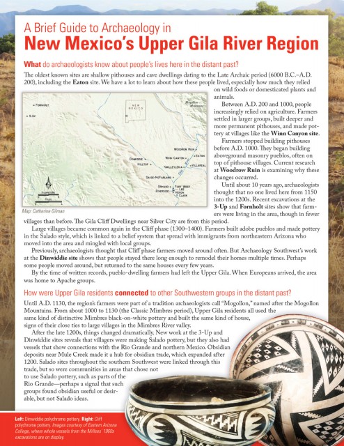
Between A.D. 200 and 1000, people increasingly relied on agriculture. Farmers settled in larger groups, built deeper and more permanent pithouses, and made pottery at villages like the Winn Canyon site.
Farmers stopped building pithouses before A.D. 1000. They began building aboveground masonry pueblos, often on top of pithouse villages. Current research at Woodrow Ruin is examining why these changes occurred.
Until about 10 years ago, archaeologists thought that no one lived here from 1150 into the 1200s. Recent excavations at the 3-Up and Fornholt sites show that farmers were living in the area, though in fewer villages than before. The Gila Cliff Dwellings near Silver City are from this period.
Large villages became common again in the Cliff phase (1300–1400). Farmers built adobe pueblos and made pottery in the Salado style, which is linked to a belief system that spread with immigrants from northeastern Arizona who moved into the area and mingled with local groups.
Previously, archaeologists thought that Cliff phase farmers moved around often. But Archaeology Southwest’s work at the Dinwiddie site shows that people stayed there long enough to remodel their homes multiple times. Perhaps some people moved around, but returned to the same houses every few years.
By the time of written records, pueblo-dwelling farmers had left the Upper Gila. When Europeans arrived, the area was home to Apache groups.
How were Upper Gila residents connected to other Southwestern groups in the distant past?
Until A.D. 1130, the region’s farmers were part of a tradition archaeologists call “Mogollon,” named after the Mogollon Mountains. From about 1000 to 1130 (the Classic Mimbres period), Upper Gila residents all used the same kind of distinctive Mimbres black-on-white pottery and built the same kind of house, signs of their close ties to large villages in the Mimbres River valley.
After the late 1200s, things changed dramatically. New work at the 3-Up and Dinwiddie sites reveals that villagers were making Salado pottery, but they also had vessels that show connections with the Rio Grande and northern Mexico. Obsidian deposits near Mule Creek made it a hub for obsidian trade, which expanded after 1200. Salado sites throughout the southern Southwest were linked through this trade, but so were communities in areas that chose not to use Salado pottery, such as parts of the Rio Grande—perhaps a signal that such groups found obsidian useful or desirable, but not Salado ideas.
Why do archaeologists study the Upper Gila? And how do they know what they know?
Researchers have been investigating archaeological sites here since the 1920s. Archaeologists undertook so much important work here on the period between 1300 and 1400 that they named it the “Cliff phase” after the Cliff Valley. Research here all but ceased after the 1970s.
That early research focused on identifying groups of people who shared similar pottery and architecture and on creating lists of plants and animals they used. Today, archaeologists build on that work by asking different questions. What does the fact that people shared a pottery style mean? As expanding populations needed more food and firewood, were some types of wild animals and plants more reliable?
Today’s questions require different kinds of data. This is why Archaeology Southwest excavates only small portions of sites—if we excavate at all—so that deposits remain for future examination with new methods and questions.
We answer some questions without shovels. For example, we can address some questions about ancient populations and population movement by recording information from the surfaces of sites. Making maps and counting types of pottery sherds allows us to recognize sites from understudied periods without breaking ground.
We also examine (and reexamine) information from other excavations in the region, including those undertaken by Jack and Vera Mills in the 1960s.
What happens to artifacts and sites after the archaeologists leave?
Collections in museums are permanently cared for and available for study. Older collections stored privately are often lost; such is the case with the broken pottery sherds excavated by the Millses. Collections from Archaeology Southwest’s excavations are stored at the Arizona State Museum, where they will be publicly accessible and available for future study and exhibition.
Many archaeological sites in the Upper Gila are on private land, and local families continue to protect these places of the past. Archaeology Southwest works with landowners and other stakeholders to develop protections that will help people steward sites for the future.
Want to learn more? Explore the major concepts, places, cultures, and themes that Southwestern archaeologists are investigating today in our Introduction to Southwestern Archaeology.