• Donate
    • Donate
    • Member Circles and Benefits
    • Become a Member
    • Renew Today
    • Give a Gift Membership
    • Student Membership
  • Take Action
    • Volunteer Program
    • Make Your Voice Heard
  • About
    • Land Acknowledgment
    • What We Do
    • Position Papers
    • Team & People
    • Job Openings
    • Partners & Friends
    • Annual Reports
    • Policies & Financials
  • Things to Do
    • Events
    • Archaeology Café
    • Exhibits
    • Classes
    • Field School
  • Explore
    • Free Resources
    • Introduction to Southwestern Archaeology
    • Projects
    • Protection Efforts
    • Ancient Cultures
    • Videos
    • Places to Visit
  • Store
    • Archaeology Southwest Magazine
    • All Products
  • News
    • Blog
    • Press Releases/Announcements
    • Preservation Archaeology Today
    • Sign up for E-News
  • Donate
    • Donate
    • Member Circles and Benefits
    • Become a Member
    • Renew Today
    • Give a Gift Membership
    • Student Membership
  • Take Action
    • Volunteer Program
    • Make Your Voice Heard
X
  • About
    • Land Acknowledgment
    • What We Do
    • Position Papers
    • Team & People
    • Job Openings
    • Partners & Friends
    • Annual Reports
    • Policies & Financials
  • Things to Do
    • Events
    • Archaeology Café
    • Speakers Bureau
    • Exhibits
    • Classes
    • Field School
  • Explore
    • Free Resources
    • SW Archaeology 101
    • Projects
    • Protection Efforts
    • Ancient Cultures
    • Videos
    • Places to Visit
  • Store
    • Archaeology Southwest Magazine
    • All Products
  • News
    • Blog
    • Press Releases/Announcements
    • Preservation Archaeology Today
    • Sign up for E-News

Tracking Canals in the Safford Basin: A Tale of Fate 34 & 54 Years in the Making

Preservation Archaeology Blog
  • Home
  • >
  • Preservation Archaeology Blog
  • >
  • Tracking Canals in the Safford Basin: A Tale of Fa...

By James A. Neely, Professor Emeritus, University of Texas at Austin

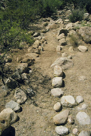
This story begins in the summer of 1994, when I accompanied Kyle Woodson—one of my graduate students at the University of Texas at Austin—into the field to get him started on excavations for his master’s thesis project at the now well-known site of Goat Hill. Seeing that Kyle was most competently conducting that task, I began to wander around the site to see what I could see. It was then that I discovered the first of many water management features, a very clearly defined rock-bordered canal (Figure 1). This led to a further examination of the Lefthand Canyon area, with Goat Hill situated at its southern extreme, and my recording of an extensive agricultural complex of terracing and canals, evidently associated with the Goat Hill site.

Rock-Bordered Canal near Goat Hill
Figure 1: A well-defined portion of the rock-bordered canal located just west and below the Goat Hill site in the south segment of Lefthand Canyon. The interior of the canal channel is about 50 cm in width; note the ten-centimeter-long scale at the left interior edge of the channel in the middle ground.

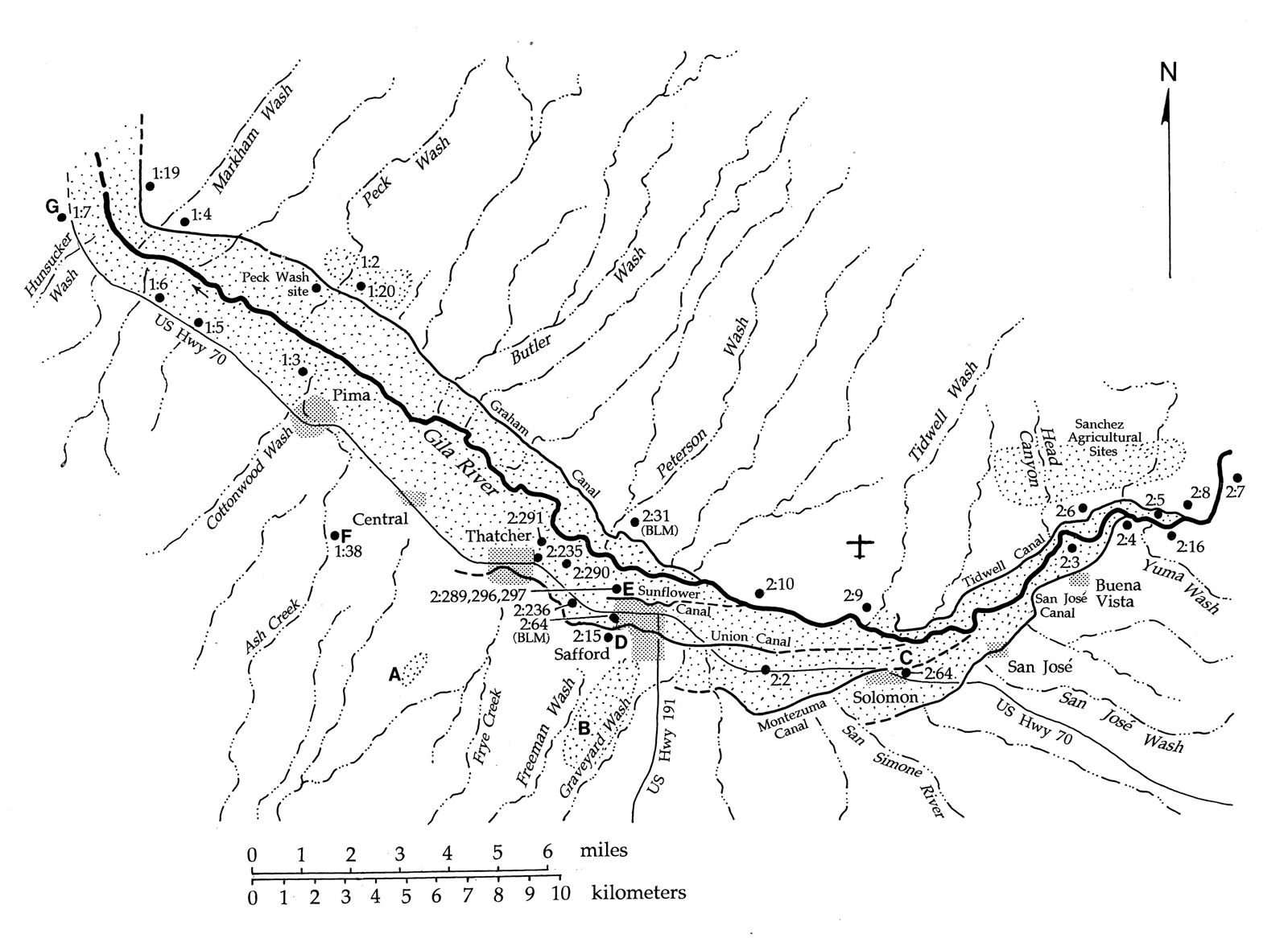
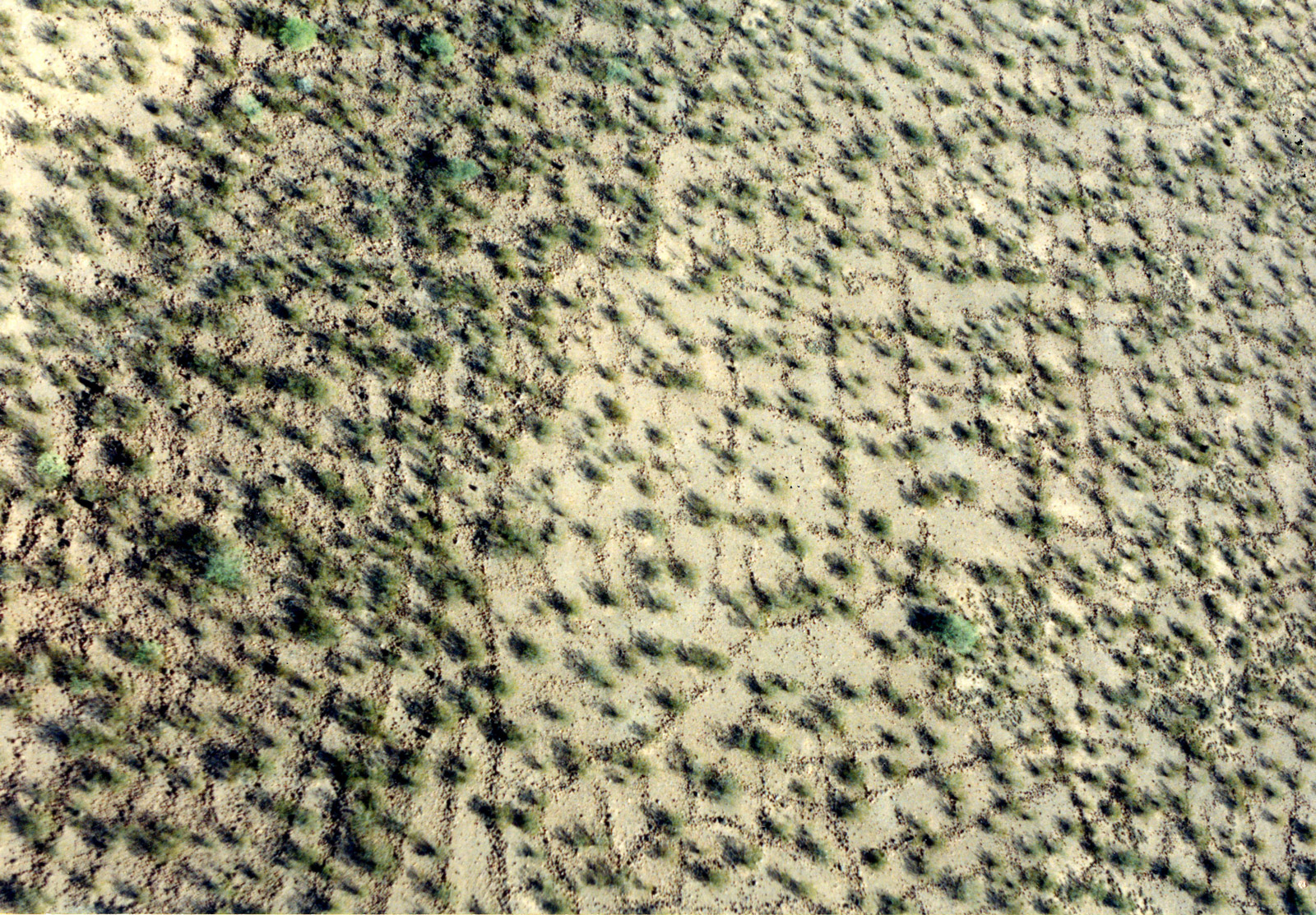
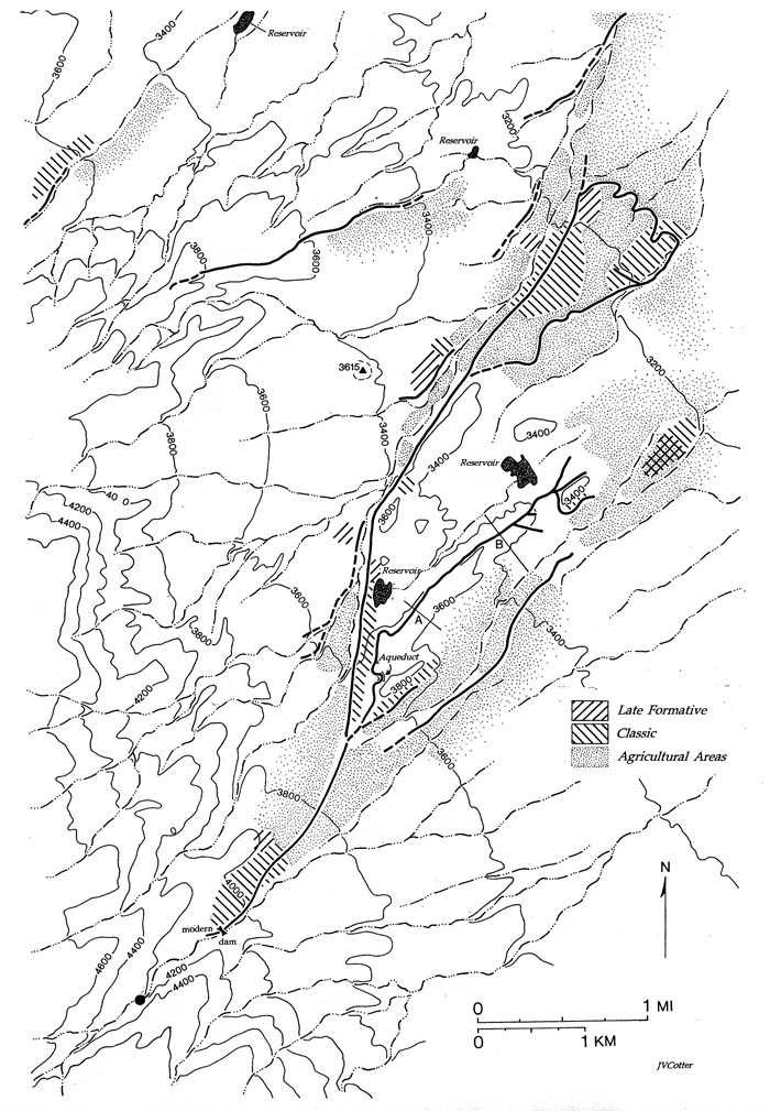
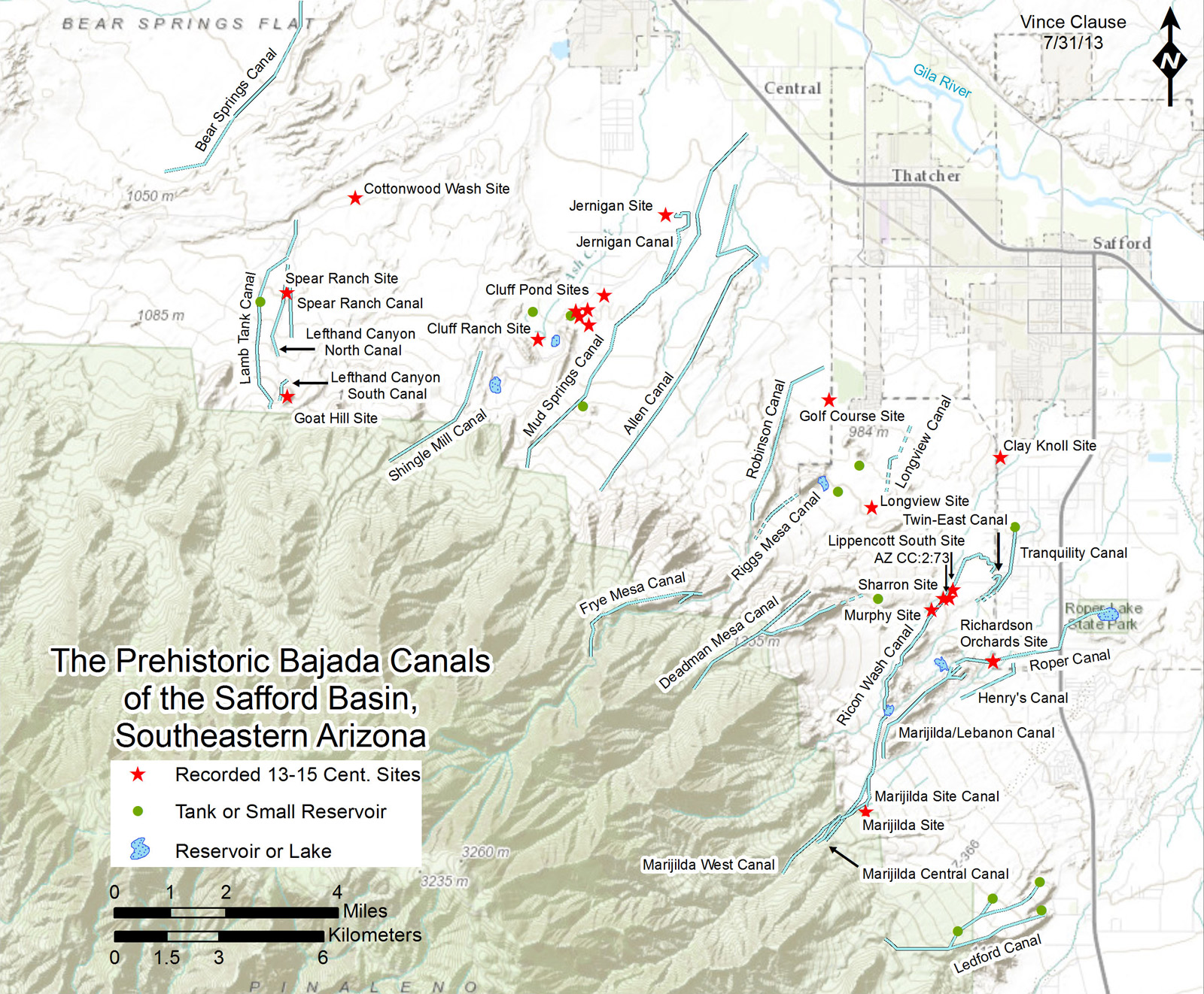
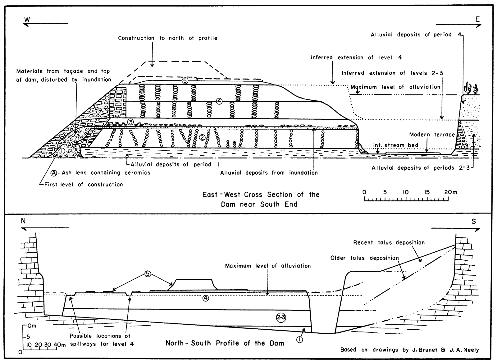
The Lefthand Canyon survey led me to expand my research in the Safford Basin. My next project was to attempt a reconstruction of the prehistoric Gila River canal systems in the area (Figure 2). My collaboration with William E. Doolittle in a study of the Safford Valley prehistoric gridded fields (Figure 3) followed. Since my retirement—as I do not play golf—I have undertaken two additional research projects: a stratified survey of the archaeological sites and canal systems in the Marijilda, Rincon, and Graveyard Wash area (Figure 4) and a survey focused on recording the bajada canal systems emanating from the north side of the Pinaleño Mountains (Figure 5).

Map of Safford Basin
Figure 2: Map of a portion of the Safford Basin centering on the City of Safford. This map shows the canals proposed to have prehistoric counterparts. The numerals (e.g., 2:290) represent the grid square and site number in the Arizona State Museum (ASM) site survey (AZSITE) system. The state and quadrangle designations (i.e., AZ and CC) have not been included due to lack of space. Note that sites 2:31 and 2:64 are from the Bureau of Land Management (BLM) survey files. The stippling paralleling the Gila River approximates the extent of the floodplain and lower terraces available for irrigated cultivation. Click to enlarge.
Rock-Bordered Grid Fields
Figure 3: Aerial photograph of a portion of the rock-bordered grid fields with rockpiles and checkdams that cover the first terrace north of the Gila River in the vicinity of Pima. The steeper slope shown in the left portion of the photo has contour terraces that have been divided into grids. Click to enlarge.

Topographic Map of Survey Area
Figure 4: Topographic map of the Marijilda, Rincon, Graveyard Wash Survey area on Arizona State Lands. The dark solid and dashed lines indicate the prehistoric canals and probable canals recorded. The hatched areas represent site clusterings by initial estimated period of occupation. This map will be superseded by one showing the specific locations of the archaeological sites recorded. Click to enlarge.
Safford Bajada Canals Map
Figure 5: Topographic map showing results of the Bajada Canals survey project. Click to enlarge.

Since 1994, I have been dividing my research between the Safford Basin and the Tehuacan Valley of southern Puebla, Mexico, working on reconstructions of the prehistoric agricultural strategies and water management (Figure 6). In each of these areas, the preservation of ancient fields and water management infrastructure is excellent, and the technologies are extremely varied and quite sophisticated.

Sections of the Purrón Dam
Figure 6: Longitudinal and transverse sections of the Purrón Dam located in the southern part of the Tehuacan Valley of Puebla, Mexico. This is the largest single water management feature found in Mesoamerica. After Woodbury and Neely 1972: Figure 8. Click to enlarge.

During my early days of fieldwork in the Safford Basin, a number of dedicated, hard-working students from the University of Texas provided assistance. Safford resident Everett Murphy, then an archaeological site steward for the area, also most ably assisted me. His knowledge of the landscape and sites was invaluable and saved me much time in the field. Most recently, Thatcher resident Don Lancaster has assisted me, both in the field and in searching satellite imagery, in the expansion of my study of the bajada canal systems extending northward from the Pinaleño Mountains. His love of walking in the desert has greatly augmented the number of bajada canals in our assemblage.

So, where does the “… Tale of Fate …” come into this story? Well, 1994 marked 34 years since I first visited the Safford Basin as a graduate student at the University of Arizona, on a spring semester 1960 Southwestern Archaeology field trip led by Drs. Raymond Thompson and Emil Haury. One stop on the field trip was the Safford Basin, where Thompson and Haury related to us neophytes the importance and potential of the basin in the study of the then relatively young concept of the Salado Culture. Sidetracked, I strayed into projects in Ecuador, Iran, Mexico, and other parts of the American Southwest before I returned to the Safford area, where I will begin my 54th year of fieldwork this spring.


5 thoughts on “Tracking Canals in the Safford Basin: A Tale of Fate 34 & 54 Years in the Making”

  1. Dan McGrew says:
    April 3, 2014 at 2:38 pm

    Super Awesome Jim
    Dan

  2. Don Lancaster says:
    April 3, 2014 at 4:28 pm

    Additional ongoing resources on the Safford area bajada hanging canals can be found through http://www.tinaja.com/tinsamp1.shtml

    don@tinaja.com

  3. Matthew LaFevor says:
    April 4, 2014 at 7:10 am

    Wow. I’ve got to get out there!…thanks, Jim

  4. Donna Tang says:
    May 2, 2014 at 11:00 am

    I visited the Marijilda site with Bill Gillespie of the BLM several years ago, and observed the amazing canals and field systems. Thanks for expanding my acquaintance with this incredible ancient technology!

  5. Julia Fonseca says:
    May 3, 2014 at 4:47 pm

    I recently visited the area with Jim and Don. Very impressive; truly a cultural landscape. Great illustrations, by the way.

Comments are closed.

Explore the News

  • Preservation Archaeology Blog
  • Press Releases/Announcements
  • Preservation Archaeology Today
  • Join Today

    Keep up with the latest discoveries in southwestern archaeology. Join today, and receive Archaeology Southwest Magazine, among other member benefits.

    Become A Member

Want to help us? Make a donation

or take action

Cyber SouthwestRespect Great BendHands-On ArchaeologySave History

© 2025 Archaeology Southwest

520.882.6946
Contact
  • My Store Account
  • Contact Us
  • Terms of Use
  • Privacy Policy
  • Press Room